|
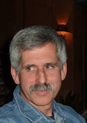
The day before we were to leave for our Sierra challenge, my good friend George Johnson passed away after a short battle with pancreatic cancer. He was 61. In that time, he spent 32 years as a volunteer firefighter, retiring in 2010 as a captain. He also had a small apple orchard and Christmas tree farm which was a special place to be in late autumn. For me, George was a mentor, subtly teaching me what it is to be a volunteer fire captain, especially how to represent all corners of a large and diverse response area. He will be missed.
Though I'm repeating this from previous stories, I can't think of a better way to say it. For me, the PMC is a metaphor for such battles. Cancer is an arduous journey, often filled with pain and suffering. People sometimes ask me why we make our ride difficult. This is why.
We've got a lot of ground to cover, as this was an action-packed weekend. Though I sprinkled a few pictures in here. Part trip advisor, part ride log, this is a pretty long story, because it was big adventure. Click on any picture to enlarge.
|
Training and ride planning
I wanted to ride more this year than last. Though I say that pretty much every year, this time I was serious. I rode about 2600 miles through September 5, far more than last year. Many rides were longer rides. Somewhere along the way I adopted a mantra: no lazy riding. Any time I found myself slacking, I'd pick up the pace. It took a while to see the sort of times I was looking for, but eventually, in late July, I started to see the results, setting some personal best times on local climbs. Certainly the strongest rides I've done in a few years. I was ready for our PMC-west.
|

|
|
The Route and The Plan
I came up with this route a few years back while vacationing in Yosemite National Park: a ride across Tioga Pass, from the west side of the park to the east side, and then continuing south to Mammoth Mountain. It is a challenging ride in the calmest of conditions - 106 miles and over 12000 feet of elevation gain. And we're not working at sea level. The ride starts around 4500', climbs through 9954’, and meanders around 7500 to 8800 for a good part of it. PMC-west veteran Steve Meier would join me again. Since it's a one way ride, and an opportunity to go to Yosemite (one of our favorite places), Beth would join us.
|
|
|
In an effort to minimize traffic (Yosemite is a very busy place!), we planned to ride after Labor Day, on a weekday. Seemed sensible. Though sometimes things that make sense don't quite work out. Our objective was to head out Saturday and spend a day and a half acclimating to the altitude. We'd stay at the Evergreen Lodge near the Hetch-Hetchy reservoir and not far from the Big Oak Flat entrance to Yosemite. Beth and I have stayed at Evergreen many times (we highly recommend it!) Then we'd ride on Monday. Beth would leap-frog us and meet us about 30 miles in so we could get some food and water, then could go off hiking for the rest of the day, and we'd all meet up on Mammoth Mountain, and stay overnight.
|
You know what they say about the best-laid plans...
Where there's smoke...
We arrived at Evergreen mid-day on Saturday and headed down to the Hetch-Hetchy for a light hike. We had a nice dinner at Evergreen, which has a really good restaurant and bar. Steve put away a full rack of ribs. "I'm fat loading", he said. He does have some funny ideas 
On Sunday morning, after an Evergreen breakfast, we set out towards the high country. It was a nice sunny day, expected to be in the 80s around Evergreen, low 70s on Tioga Pass. We were scoping out locations for our one "supported" rest stop where we’d meet Beth; we had other convenient places to stop after that (there are places to get food and water about every 20-30 miles starting at Tuolomne Meadows). We selected the Yosemite Creek trailhead for our first stop.
Moving on, we stopped at Olmstead Point to observe Half Dome and the little Meadow fire, which was about 10 acres in size. In a very remote location, it had been burning since mid July. The picture at right shows us with Half Dome in the background and a bit of smoke at 11:30AM.
We found a spot about a mile from the park exit, at about 9800', and went for a nice 45 minute hike. When we got back to the car, we decided to have a light lunch, then Steve and I would ride around a bit at this elevation and we'd all meet at Tenaya Lake. Just as we were suiting up for the ride, we noticed an ominous smoke cloud passing overhead. It was hard to tell if the fire was just beyond the trees, or if it was drift smoke from a more distant fire. We decided to "ride now, while we can" and dispatched Beth to get some info at the Tuolomne visitor's center. It was about 1:30PM.
Many of you probably read or saw news about what had happened. Our little Meadow Fire had changed. A later description from the park service web site said:
"
The fire is in an area designated as wilderness in Yosemite National Park, within the Little Yosemite Valley, Mariposa County. The original fire was impacted by a wind event that caused the fire to spread significantly on September 7th 2014.". It was windy, that's for sure. Conditions do change in a hurry. By the time we got to Tenaya Lake, about 6 miles from the fire, we were seeing cinders falling from the sky. The fire was already about 400 acres. On the way back to Evergreen, we were talking about various plans B just in case Tioga Pass was closed to traffic on Monday. We stopped at Olmstead Point to watch the planes and helicopters. Below, our hike at 1PM, the smoke at 1:30, and a view from the same spot from earlier at Olmstead Point at 2:30.
|

|
Evergreen Lodge
|

|
| The Hetch-hetchy reservoir
|

|
| View of the little Meadow Fire from Olmstead, 11:30AM
|
|
|

|
Hike near Tioga Pass, 1PM
|
|

|
| What the heck is that? 1:30PM
|
|

|
Now big Meadow Fire from Olmstead, 2:30PM
|
|
|
Every day, we’d been checking the weather forecast. For Monday, the forecast was still mostly sunny, 20% chance of isolated thunder storms after 11AM; pretty much unchanged for days. The actual PMC, back on August 2nd, was very wet. Not a problem for us, right? This is California! It's September! Well, around midnight, we were awakened by thunder....
|
Ride Day
We had planned to start around 8am. No real rush. We’d allowed for 8 hours of riding, plus stops, plus any mechanical issues (flats, etc.). We were awakened again around 5am by a little more thunder and some light showers. Really? At the park entrance, we found out that Tioga Pass was open; the ride was on! It was damp from an earlier shower, and we started around 8:30. There's no more than about 0.1 mile warm-up here before we're on the first, most difficult climb of the day -- about 12 miles long, climbing from about 4600' to over 7000', a gain of about 2800'. The first 2 miles is a 6% grade followed by a short flat. There are even a few little descents. Overall, it's a good steady climb, with a few short 15% sections. We were feeling pretty good, and we were both cautioning the other that we still had 100 miles to go and that racing up the first climb was not in the plan. It was cool, but comfortable.
The sun would peek out periodically, and it looked like it might just be a partly cloudy day with occasional showers. Near Crane Flat where we turn onto Tioga Pass road, we could hear thunder in the distance. We had some intermittent rain, and wet roads. We continued reminding each other to keep off the slick road paint and watch our speeds on the descents. The traffic was worse than expected. The park had closed a lot of trails due to the Meadow Fire, so we suspected that people were coming up to the high country instead.
In this first segment, there is fire damage everywhere you look. In the first few miles, to the left, there is evidence of last year's 250,000 acre Rim Fire. After Crane Flat, to the right, evidence of the Foresta Fire from some years back. There are also places where older fires from decades back have given rise to new growth. Some areas look like little Christmas tree farms.
I took a moment to remember George, and I was glad for the memories.
Yosemite National Park is a magical place.
Change is gonna come
We completed the first climb and continued along towards Yosemite Creek. We saw some road construction signs and eventually a line of stopped traffic around 18 miles in. One of the pilot cars allowed us to get to the front of the cars so we could then wait for all of the cars to pass. Fair enough, I'd rather follow than be side-by-side with a bunch of RVs. We were told it would be about 10 minutes before we'd get going. More thunder. And then... the rain came. Heavy, cold rain. It would have been bad enough riding in it. It was worse just standing there. The temperature dropped from about 58 to 48. After waiting for 15 minutes for all the cars to pass, we got going, completely soaked and freezing. At least climbing generates some heat.
As this remnant of Hurricane Norbert passed through, we had alternating showers and downpours, mixed with erratic winds. The heavier rain often seemed to coincide with the downhill sections, making them particularly slow. I have pretty reasonable bike handling skills, but between the rain, the traffic, and the cold, it was a real challenge to keep the bike straight.
|

|
Wakey Wakey! Big Oak Flat Entrance
|

|
Ready, set, ...
|

|
Steve's all smiles, 1.5 hours in...
|

|
Unscheduled construction stop
and unsettled weather ahead
|
|
|
The plus side? Steve is extremely positive throughout. He was singing songs about sunshine, and there might even have been a chorus of Doo Wah Diddy! He also provided a good reminder to rotate hand positions. More good stuff: we had about 15-20 minutes without a single car passing us, since the construction had stopped the cars behind us. That was not bad! As cars started to show up again, we stopped at a scenic overlook just before our planned stop. Beth passed us here, perfect timing. At about 27 miles in after a cold descent, we’d arrived at the Yosemite Creek trailhead. Food and water. Roasted red potatoes; banana bread. A little pasta salad. Perfect.
Beth did notice that I was shivering a bit. "No one would think worse of you if you stopped", she said. "Nope, I'm just trying to keep warm!", I replied, while struggling to operate a zipper with cold fingers. I thought about changing into spare shorts and jersey, but I've only got one jacket - a windbreaker. Now soaked. As well as my shoes and socks. We've still got 80 miles to go. I might need the dry clothes later. Plan? Carry on.
|

|
| Descending to Yosemite creek
|
|

|
| The area around Yosemite Creek
|
|
|
Olmstead Point to Tioga Pass
As long as we were climbing, all was good. We warmed up; the rain would stop for a bit; we'd dry out a bit. Beth had already given up on hiking and was scouting out the road ahead. At one point she passed us going the other direction. She had been up to Tenaya Lake where the smoke was thick. "Choking" was the word she used later. The Meadow Fire had grown to 2500 acres. She got some pictures of us and stayed nearby just to make sure we didn't need a ride past the smoky section. But by the time we got to Tenaya Lake, the wind and rain had washed a lot of the smoke out. Honestly, I didn't even notice. We had more rain between Tenaya and Tuolomne Meadows. Steve joked, "I think we have proven our manliness today" just as Beth was getting the picture seen below. We met Beth at Tuolumne for food and water. At this point, we were still in a reasonable position to finish on time but we'd used up most of our buffer. We decided to regroup at the park exit, 8.5 miles ahead.
From Tuolumne Meadows to the park exit the road rises from 8500' to just shy of 10000'. Beth got these pictures along the way. The view opens up a bit so you can see a good distance. I told Steve "Wouldn't it be nice if we could clear the park without another downpour?" We were discussing "the big descent" from the park exit to Lee Vining. It's 12 miles long, and drops 3000 feet. Parts of it are a 12% grade. It isn't very technical, but it is VERY fast. We basically agreed that if it was dry, we'd consider it. As we got within a mile of the park exit, we could see dark clouds ahead, and it started to rain again. And it was really cold. 43 degrees. I am sure a few bits of hail bounced off my helmet.
|

|
Coming into Tuolumne Meadows after
another downpour. More weather ahead
|
|
|

|
| Hard to frown with Steve around!
|
|

|
| Climbing is hard at over 9000 feet
|
|

|
| It's no Everest, but it's work
|
|
|
This Scene Deleted
Even though Beth was waiting at the park exit with the mobile warming hut, Steve was determined to get through the gate and wanted to do a little piece of the descent. "How about we just try to get down to my fishing hole, Lee Vining Creek?" he suggested. This turned out to be not the best idea. About 100 feet past the park exit the next squall hit. 30mph crosswinds, and driving rain. I could barely see. We pulled over about a mile down near Tioga Lake and abandoned the descent on the basis of safety. Even on a clear day it's a tricky descent. In this weather?
It was 3pm. We'd done 55 miles so far. Many extra stops. Very slow going. It was nice and warm in the car. It felt good to warm up on the way down to Lee Vining. Should we hang it up? It wasn't raining much in Lee Vining, so we decided to pick up the route at the start of the June Lake Loop. We'd have about 34 miles and 3600' of climbing to go. We might finish just about on time.
Second Ride
Beth dropped us off at the start of the June Lake loop, then headed for Mammoth to find our hotel. For us, although there was not much rain on the June Lake Loop, there was quite a headwind coming off the mountains. Also, after a 20 minute stop, it is really difficult to get moving again. As we got into the canyon that forms the lakes, we were able to move at a better pace. Just past the town of June Lake, the road starts to turn up back towards US 395. Just before the climb starts, Steve pointed out "Yeah, there is a stinger right here". It's about 10%. In this section, it was just about warm enough to ditch the jacket. 63 degrees. The last part of the loop is a pretty zippy descent, straight as an arrow. This was the first dry descent of the day. We made our last water stop of the day at a gas station at the June Lake / 395 junction, then headed south on 395.
Although a major highway, it's really not bad to ride on 395. It has huge shoulders and not a lot of traffic. I was having some trouble developing power in the flatter parts - my own shoulders were pretty beat up from gripping the handlebars during the first ride. And the altitude, although not obviously noticeable, was having some effect. It was still quite breezy - crosswinds here. Some of the descents were tricky with the crosswinds. About 9 miles of ups and downs brought us to the last leg - the Mammoth scenic loop.
When we were stopped, I was texting Beth with position updates. Our plan of course was to finish at the top of the ski resort, where the lifts start, at 8900'. In one response she texted "Could meet @ hotel. Shorter ride, no climb ". Literally. Including the smiley. I passed this on to Steve. "NO WAY. We ARE climbing to the Mammoth!" The scenic loop is very quiet (few vehicles), and has a bike lane the whole way. The start of it basically faces the same direction as the start of the June Lake Loop - into the mountain. So, back to the headwinds. There's one point where the road switches back and turns up. For whatever reason - possibly motivated by the idea of a hot shower and a pizza - this is where my second wind kicked in. We picked it up to about 10 mph and crested the climb. The second dry descent of the day was about a mile long. At the intersection with Hwy 203, we turned right, and it was about 3 miles up to the finish, with the last 600' of climbing. The beginning of the climb was really quite nice. About 6%. I would move along at a good pace, then need a minute or two to recover, then repeat. At one point, I told Steve I didn’t think there was really a Mammoth up there. He assured me there was. It took only about 23 minutes to cover the last 3.25 miles. It felt good to be done. And good to know there really is a Mammoth.
|

|
We'll take a rain-check for the descent
|

|
Pointing back at Yosemite on the
June Lake loop. Still some big clouds.
|

|
| June Lake
|
|
|

|
| On the last climb to Mammoth
|
|

|
| Strong finish!
|
|

|
| Yes, there is a Mammoth.
|
|
|
Post ride
It was a long and challenging day. We came up a bit short on the miles (91), but did virtually all of the climb - about 11700'. This was a really challenging ride. I'm a warm/hot weather rider, and I was really not prepared (clothing-wise) for this sort of weather. The long stops and the wind really slowed us down. But had we been able to do the big descent, we would have been close to the bottom end of our estimated average speed, which surprises me, but you can't argue with math! My legs were in pretty good shape, surprisingly. Knees as well. Most of the soreness was shoulders, hands, and my jaw. Steve's positivity helped keep me going, there's no question about that. He is indefatigable, and retained a high spirit throughout the ride.
After a good hot shower, we made our way to John's Pizza Works in Mammoth which is a local hangout and very good. Try the garlic breadsticks! We toasted completion of a major challenge, and the best mobile warming hut and support staff (thanks Beth!). Finally, we raised a glass to George.
|

|
| Pizza Works for me!
|
|

|
| Tuesday morning coffee
|
|

|
| Tuesday brunch at Whoa Nellie Deli
|
|
|
The Day After
In the morning, there wasn't a cloud in the sky. The storm was gone. Temperatures back to normal. We should have ridden today! We had a nice breakfast at Looney Bean Coffee then started the trip back. We stopped at Mono Lake, then had lunch at the Mobil at 395x120. Don't let the gas station fool ya! There is a great restaurant, The Whoa Nellie Deli, inside the Mobil. Try the caesar salad with skirt steak!
It was still a little breezy going back up to the park, and we briefly mused about doing the descent now - maybe some other time. We made a few scenery stops along the way, and Steve just had to have a swim in Tenaya Lake. The smoke was not bad. The Meadow Fire was at about 4000 acres. One interesting observation - there was a ring around the lake on the beach. On closer inspection, the ring was bits of charcoal - embers had fallen in the lake and the current pushed them out to the edge. After one more look back at the fire from Olmstead, we made the trip back to the Bay Area.
|

|
| Mono Lake - a truly strange place
|
|

|
| Tuolumne River
|
|

|
| Tenaya Lake - notice the black ring
|
|

|
| Granite formations at Tenaya Lake
|
|
|
Parting words
The actual PMC had been a gully washer - I guess it's only fair that we had challenging weather as well. We did cross the Yosemite high country, gate to gate. We did almost all of the promised climbing. Even though we had to give up the Tioga descent, if you include the Sunday warm-up ride, we did the full ride. We had plenty of food and water. We had no mechanical issues, and although the course was a bit slick in spots, with some very scary conditions, we had no mishaps or injuries. The company was great! Beth did an awesome job looking after us. She could definitely give some how-to-drive-with-bicycles lessons to a bunch of other drivers! But I owe her a return trip to Yosemite for some long hikes. I would not characterize the ride as "miserable", but it would have been challenging enough with the original forecast, or with maybe one of the extra 4 challenges thrown in our direction. We did not give up because we could still turn the pedals and because it’s the PMC.
What next? I'm wearing a purple bracelet which says "Find a Cure for Pancreatic Cancer". That would be a great thing but it is likely a long way off. There are many clinical trials in process at many places, including Dana Farber, looking at new and better treatment options. But the big problem with pancreatic cancer is that it is most often discovered very late in the game. Finding a reliable early marker has been elusive, but the search continues.
Thanks for your support!
|
In memory of George Johnson
1952 - 2014
|


